ELGLers State of Place share a highlight from the International Downtown Association Conference.
HIGH DRAMA IN CANADA? THOUGHT THAT WAS ONLY A U.S. THING…

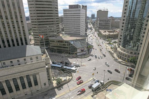
A roundabout at the iconic intersection of Portage and Main would work for vehicles and pedestrians.
When we heard about the one-year plus controversy around the idea of once again allowing pedestrians to cross at Portage and Main (Canada’s most famous intersection, it seems!), it was a no-brainer that State of Place was just what proponents of elevating Downtown’s walkability needed to turn Nays into Yays and win support for this important project. In case you haven’t heard about the “brawl” that’s been brewing between Mayor Brian Bowman & Councilman Jeff Brotway, here’s what you need to know:
- 1979: City signs deal to block off Portage and Main to pedestrian traffic for 40 years
- Aug 2014: As part of his mayoral campaign, Bowman pledges to reopen the intersection of Portage and Main to allow pedestrians to cross at the street level instead of having to cross via an underground walkway that is part of Winnipeg Square mall
- June 2015: City Council votes to allow study of the impacts of reopening the intersection to pedestrian traffic
- Mar 2016: City commissions Dillon Consulting to conduct a $116K study to assess options for re-establishing pedestrian crossing at Portage & Main
- Nov 2016: Portage & Main study complete but not released publically; concludes project would cause delay to vehicle traffic times and transit service
- Dec 2017: Brotway says project would cost $1M plus additional transit costs of $7M
- Mar 2017: Brotway demands Dillman study to be publicly released
- Jul 2017: Hmmm… official gridlock
THERE’S GOTTA BE A BETTER WAY!
Are you keeping track? So that’s four years, at least $116K and counting (more if you count lost time) with no end in sight… all to decide whether or not to take down some pedestrian barriers? Really? Seriously? It’s 2017. This. Shouldn’t. Take. This. Long. To be fair, this Winnipeg War is all too common. There are countless plans for making places better that should just be no brainers. We all know what inherently good design is. We all know what is good for pedestrians. We all know what more and more people are looking for – walkable, livable places. And there are many amazing designers and planners (who I have affectionately referred to as “the Usual Suspects”) equipped to create awesome schemes to make these kinds of places come to life. And yet…four years and counting and nothing. And that’s not even the worst case scenario. Some plans don’t see the light of day for over a decade…hence all that “notorious” dust being collected. Why?
NAYSAYERS GONNA NAY!
The truth of the matter is, there are still stakeholders that don’t buy your vision. And they’re often equipped with “data” that proves their point. And you’re bringing (beautiful) pictures to fight your battle. It’s time to fight fire with fire. It’s time to bring your own gun to the gunfight, as one of our favorite customers, and big-time IDAer, Raphael Clemente of West Palm Beach Downtown Development Authority loves to say. It’s time to create your own “data-driven” story about the power of place. So without further ado, we’ve taken the liberty of doing just that. We analyzed the existing conditions of Portage and Main and the five blocks that intersect it and ran a scenario analysis to see what the impact would be of transforming this uber car-oriented street into a pedestrian wonderland – both in terms of quality of place and the economic bottom line. TLDR – the results are AMAZING!!
BUILD IT SO THEY CAN WALK – AND MAKE $$$ WHILE AT IT!
We’re not trying to toot our own horn (too much!), but the analysis below took a matter of hours to put together, and most of that was spent collecting data for the six blocks included in our report (and soon, we’ll automate that so it’ll be done in seconds). Compare that to four years and potentially two more years to go…Save time and money and maximize the bang for your buck (ahem, estimated at $18+ ROI) – who doesn’t want to do that?
Here’s what we did:
- Collected data (via Google Street View) on 290+ built environment features (e.g., crosswalks, curbcuts, vehicle lanes, sidewalks, etc.) on six blocks. (see map below)
- Using our algorithm, calculated the State of Place Index (score from 0-100) that indicates each block’s quality of place and walkability
- Created the State of Place Profile that breaks down the Index into ten sub-scores that provide a snapshot of an area’s built environments assets and needs (what’s working – what’s not)
- Ran a Sim-City style analysis that projects the new State of Place Index if the City were to open up the intersection to pedestrians (which would impact the score for four blocks!) and make a few other changes (contact us to find out what other goodies we added to increase the score!). Here’s a peek at all the potential changes you could make.
- Used our predictive analytics to estimate an ROI calculation that shows the economic upside of investing in making Downtown Winnipeg more awesome (aka pedestrian friendly) that includes just one of the four affected blocks, with some assumptions about market rents, land use square footage, and project costs. We’re happy to expand to include all affected blocks and your actual data…call us! 🙂 Bottom line, even if the project did cost $7M…it would:
- Increase the State of Place Index for Portage & Main (to Mc Dermot Ave) from 43.4 to 63.6
- Generate office premiums of $5.52/sq.ft. (assuming $20 avg. office rents)
- Lead to retail premiums of $6.73/sq.f.t (assuming $32 avg. retail rents)
- Facilitate an increase of $50.22/sq.f.t in additional retail revenues (assuming $113 avg. retail revenues)
- Capture value of $126M across 10 years (based on increases in rents and revenues)
- CREATE A RETURN ON INVESTMENT OF $18.07 FOR EVERY DOLLAR SPENT